Blog
GURU supports your major economic development workflows with integrated, cutting-edge features.
6 Sure Signs Your GIS App is Outdated

When we launched our Recruit technology a little over four years ago, GIS WebTech created a wide gap with legacy technologies that had been around for years with little innovation. The result was rapid growth for our company and incredible results for our clients, most of whom set records in the year after they switched to GIS WebTech.
The predictable result? Legacy providers reacted by bolting features onto their existing apps, a low-cost approach that saves them money by extending the product life. But these legacy apps were built years ago and were never designed for these new, complex features. For the legacy provider the result may be lower costs, but for the EDO customer the result is a cluttered app with a dated feel, slow performance, and ever more confusing navigation that frustrates and deters users.
Our approach is different.
We don’t scrimp on development by bolting new features onto old apps. Instead, we invest in all-new apps using the latest in design concepts to ensure a clean user interface and easy navigation. We integrate the latest features to keep clients on the cutting edge.
The proof is in the pudding: we are retiring Recruit, the most advanced app this market has ever seen, after only four years because we are replacing it with GURU, an all-new technology. The contrast is clear. Legacy providers have not come out with a new app in a very long time, but with the launch of our all-new GURU technology GIS WebTech has done it twice in the last four years.
Let’s take a look at six obvious ways legacy apps are not keeping up.
• You cannot show data by simply dragging a spreadsheet onto the map. Modern GIS apps allow you to show local data on the map by simply assembling it in a spreadsheet and dragging it onto the map. It might be a local industry cluster or supply chain you want to highlight in a meeting with a prospect, or maybe a set of properties you have pre-screened for your prospect to review. Whatever the data, GURU provides the simplest possible means to show it: just drag and drop onto the map and GURU does the rest, instantly plotting the locations with pinpoints. And when you click on a pinpoint the data is immediately visible in the popup. Legacy apps, tied to second-tier GIS platforms, do not provide this feature.
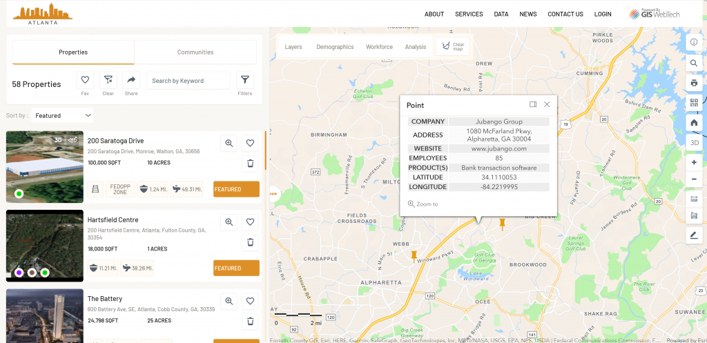
• You cannot assign data layers to open with properties. Ever wish your app would make it clear what a property’s unique assets are when a user clicks on the property? Modern GIS apps do this for you. GURU allows you to assign a set of layers, called “property layers,” that open automatically when a user clicks on the property, ensuring the user sees the property attributes you want them to see, every time. Have a great industrial property with access to high voltage power or a high-pressure gas pipeline? Simply assign those layers as “property layers” and they open automatically when the user clicks on the property, making the property’s assets crystal clear. Maybe you have an industrial property close to intermodal infrastructure. No problem, just assign that layer and it will open automatically every time a site selector clicks on the property. In other words, every site selector will see the unique data layers you want them to see for each property, every time. GIS WebTech, working with clients, invented this feature and GURU is the only app to include it. With legacy apps, all you can do is hope users discover these property assets on their own, through trial-and-error. Busy site selectors are unlikely to do so. (And, by the way, all three layers mentioned in this paragraph – high voltage power, high pressure gas and intermodal – are provided for free in GURU.)
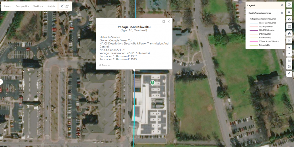
• Map layers are canned and outdated. Legacy apps do not include the latest layers like FCC broadband score or intermodal infrastructure and instead provide outdated, canned layers like ethylene crackers and coal mines. Worse, in legacy apps there is no easy way to add important local layers like sewer, water, zoning, parcels, transit, or industry clusters. You’re stuck trying to get shapefiles produced and then emailing them off to try to get them added to the app. In contrast, modern apps like GURU include the latest layers and make adding your local data layers a breeze, requiring just a few clicks. No emailing shapefiles around.
• No 3D virtual spec buildings are included. Legacy apps either lack 3D entirely or ask users to draw 3D buildings themselves using Google Earth. But busy site selectors and economic developers are not going to take the time to learn the system and then draw a building. (Plus, Google Earth is a consumer app and a poor substitute for a business-focused 3D experience. For more on why Google Earth fails as a business app, see our classic blog on the subject.) In contrast, modern apps include a full suite of free 3D spec buildings inside the app that you can add to your properties with a few clicks. You get to select the right building for the property, ensuring site selectors see exactly what you want them to see, without expecting them to figure out how to draw it themselves.

• “What’s Nearby” is not included. Virtually all modern GIS apps include “What’s Nearby” as a way to highlight local amenities, and apps for economic development should be no exception. So GURU includes “What’s Nearby” for every property, automatically, and even makes it easy to include local data you may want to include. With talent attraction a critical component of economic development and workforce a critical component of site selection, leading EDOs rely on this feature to show available amenities for properties and communities, giving them an important edge in attracting businesses and instilling confidence in those businesses that they can hire and retain critical workforce. Legacy apps lack this feature entirely and provide no data on local amenities. Businesses and site selectors are left guessing.
• Drive time and trucking time analysis are limited to 60 minutes or 60 miles. Modern apps like GURU allow users to analyze data within driving and trucking boundaries out to 300 minutes or 300 miles.
Legacy apps, in contrast, limit analysis to 60 minutes or 60 miles. In many areas of the country a 60-minute limit makes drive time analysis all but useless, and limiting trucking analysis to 60 minutes or 60 miles guarantees the feature will be more frustrating than helpful.
These are just a few examples of the many advantages of GURU over legacy apps. Simply put, GURU has widened the gap with legacy apps and created competitive advantage for EDOs using it. Best of all, GURU can fit all budgets, and even comes in a version purpose-built for rural economic development. Contact us to learn more.